KCRA 3's weather team is calling Wednesday and Thursday Impact Days because of the potential for heavy rain and gusty winds from the strongest storm headed to Northern California so far this year. Get California Storm ReadyDownload our app for the latest breaking news and weather alertsTrack live California Doppler radarSee our live traffic mapChain controls? Track the latest California road conditions informationSend us your weather videos and photosSacramento County activates respite centers ahead of storms, seeks donations ( Video below: A look at storm impacts through Thursday.) The front half of Wednesday will be dry under overcast skies with a subtle breeze. Bigger changes arrive with rain across the region by the afternoon. The winds will begin to increase during the midday and get gusty by the afternoon. Valley gusts of 35-45 mph are expected, especially after sunset. The strongest winds are expected between 6 p.m. and 10 p.m. Parts of the Bay Area could see 50 mph wind gusts. (Video below: A closer look at the forecast for gusty winds.)Rain will intensify late in the evening through the overnight. That could make for roadway flooding concerns for the Thursday morning commute in poor-drainage areas. The Valley could see an inch or an inch and a half of rainfall. The Foothills are likely to see three-quarters of an inch to an inch of rain.Chain control is expected in the Sierra beginning Wednesday evening. Snow levels will start high on Wednesday, near 6,000 feet. Expect up to a foot of snow over the passes by Thursday. Travel will likely be slow over the mountain passes through Thursday with some improvement Friday.(Video below: When to avoid Sierra travel this week.)On Thursday, rain and snow will turn showery for the afternoon and there's the chance of isolated thunderstorms as well. After a few hit-and-miss showers on Friday, Saturday looks mainly dry. The next Impact Day is Sunday because of more rain, wind and snow. | The science behind forecasts | California water agency helps analyze atmospheric river forecasts (Video below: A closer look at the wettest storms of the season so far in Northern California.)Follow our KCRA weather team on social mediaChief meteorologist Mark Finan on Facebook and TwitterMeteorologist Tamara Berg on Facebook and TwitterMeteorologist Eileen Javora on FacebookMeteorologist Dirk Verdoorn on FacebookMeteorologist/climate reporter Heather Waldman on Facebook and TwitterWatch our forecasts on TV or onlineHere's where to find our latest video forecast. You can also watch a livestream of our latest newscast here. The banner on our website turns red when we're live.We're also streaming on the Very Local app for Roku, Apple TV or Amazon Fire TV.
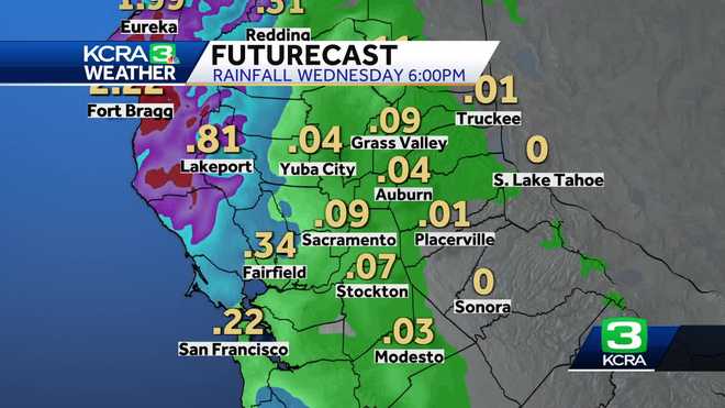
KCRA 3's weather team is calling Wednesday and Thursday Impact Days because of the potential for heavy rain and gusty winds from the strongest storm headed to Northern California so far this year.
This content is imported from Twitter. You may be able to find the same content in another format, or you may be able to find more information, at their web site.
This content is imported from Twitter. You may be able to find the same content in another format, or you may be able to find more information, at their web site.
This content is imported from Twitter. You may be able to find the same content in another format, or you may be able to find more information, at their web site.
This content is imported from Twitter. You may be able to find the same content in another format, or you may be able to find more information, at their web site.
Get California Storm Ready
( Video below: A look at storm impacts through Thursday.)
The front half of Wednesday will be dry under overcast skies with a subtle breeze. Bigger changes arrive with rain across the region by the afternoon.
The winds will begin to increase during the midday and get gusty by the afternoon. Valley gusts of 35-45 mph are expected, especially after sunset. The strongest winds are expected between 6 p.m. and 10 p.m.
Parts of the Bay Area could see 50 mph wind gusts.
(Video below: A closer look at the forecast for gusty winds.)
Rain will intensify late in the evening through the overnight. That could make for roadway flooding concerns for the Thursday morning commute in poor-drainage areas.
The Valley could see an inch or an inch and a half of rainfall. The Foothills are likely to see three-quarters of an inch to an inch of rain.
Chain control is expected in the Sierra beginning Wednesday evening.
Snow levels will start high on Wednesday, near 6,000 feet. Expect up to a foot of snow over the passes by Thursday.
Travel will likely be slow over the mountain passes through Thursday with some improvement Friday.
(Video below: When to avoid Sierra travel this week.)
On Thursday, rain and snow will turn showery for the afternoon and there's the chance of isolated thunderstorms as well.
After a few hit-and-miss showers on Friday, Saturday looks mainly dry.
The next Impact Day is Sunday because of more rain, wind and snow.
| The science behind forecasts | California water agency helps analyze atmospheric river forecasts
(Video below: A closer look at the wettest storms of the season so far in Northern California.)
Follow our KCRA weather team on social media
Watch our forecasts on TV or online
Here's where to find our latest video forecast. You can also watch a livestream of our latest newscast here. The banner on our website turns red when we're live.
We're also streaming on the Very Local app for Roku, Apple TV or Amazon Fire TV.
from U.S. - Latest - Google News https://ift.tt/72kRF8d
via IFTTT


Tidak ada komentar:
Posting Komentar