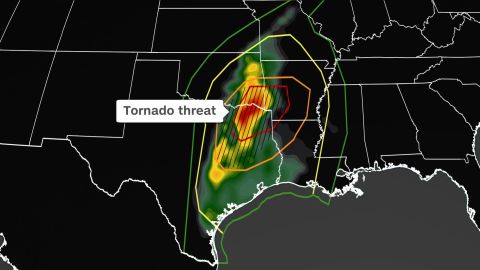
An early winter blast met record autumn warmth Friday, leading to a robust, severe storm system in the South and creating the biggest tornado threat the US has seen in more than five months.
At least one person is dead in McCurtain County, Oklahoma, where significant storm damage was reported, according to county emergency manager Cody McDaniel.
Nine twisters formed in Texas, four in Arkansas, and one in Oklahoma, a preliminary count by the National Weather Service’s Storm Prediction Center shows.
The total number will likely increase in the light of day Saturday, and the intensity of each one will not be known until local NWS offices conduct damage surveys, which may take several days.
In Texas, damage was confirmed west of Paris and near Sulphur Springs in the state’s northeast.
As the system moves east, a tornado watch is in effect Friday evening until midnight for parts of Arkansas, Louisiana, Oklahoma and Texas.

At least four houses were damaged in Hopkins County, Texas, by a tornado, the sheriff’s office there said. No injuries were reported.
In neighboring Lamar County, where Paris is the county seat, “there has been quite a bit of damage and some injuries,” Lamar County Constable Travis Rhodes told CNN Friday night.
In Oklahoma, a woman was injured by a falling tree as she was heading to a storm shelter, Lewis Collins, a volunteer at the Choctaw Office of Emergency Management, told CNN. It’s unclear whether a tornado went through the area, he said.
The Storm Prediction Center had highlighted a ‘moderate risk’ – a Level 4 of 5 – area of severe thunderstorms on Friday for eastern Texas, southeastern Oklahoma, southwestern Arkansas and northwestern Louisiana.
The Dallas-Fort Worth metropolitan area remains under an enhanced risk – a Level 3 out of 4 – for Friday.
“The most likely area for strong tornadoes [EF2 or higher] will be from far southeast Oklahoma southward into eastern Texas, to the east of the I-35 corridor,” the prediction center said.
The watch in effect until midnight includes portions of western and central Arkansas, northwest Louisiana, southeast Oklahoma, and east and northeast Texas, according to the Storm Prediction Center.
In addition to intense tornadoes, scattered large to very large hail, bigger than golf ball-sized (2 inches in diameter), are also possible, according to the Storm Prediction Center.
The main threat will shift from tornadoes Friday afternoon and evening to damaging winds going into the overnight hours as thunderstorms align and spread into Arkansas and Louisiana.
As the storms push east, a significant widespread and damaging wind event is forecast later Friday evening across portions of the Ark-La-Tex region. That is why the prediction center has upgraded the threat level for Friday.
“Storms will persist well into the night, tracking across much of Louisiana and Arkansas, and into western Mississippi, the prediction center added.
This storm system will be moving quickly from west to east, which will minimize the chance for flash flooding to occur across the Ark-La-Tex region. Farther north, rainfall of one to four inches is expected through Saturday over a broad area from Kansas to Wisconsin.
Rainfall is much needed in this region as recent drought has cause the Mississippi River to reach record low levels, impacting shipping and the supply chain.
In all, 42 million people from Texas to Wisconsin were at risk of severe storms Friday. Houston, San Antonio, Oklahoma City, Little Rock, Kansas City and Wichita are included in the risk areas as well.
The last time the greater Dallas-Fort Worth area was under an enhanced risk or higher was May 24.
Second ‘severe weather season’ in November
While tornadoes in the US can happen in any month of the year, they are most common in the spring time thanks to the clash of cold and hot air as the seasons change. The same merging of temperatures also occurs in the autumn, which is why you will often see a secondary “severe season” later in the year.
“You can see that while the spring months are our busiest time climatologically, there is a secondary increase in tornado activity in November,” the National Weather Service in New Orleans said.
Texas sees the most tornadoes (7) in the month of November on average, followed by Alabama (6), Louisiana (5), and Mississippi (5).
The time of day when a tornado occurs makes a big difference in the fatality rate. Nocturnal tornadoes are more dangerous because many people are asleep and unaware they need to be seeking a safe location. While the greater tornado threat for this particular event exists during the daytime hours, there is still the possibility for a few rotating storms through the evening hours.
Make sure you have your severe weather safety plan ready to go before bad weather hits. Know where you will go if severe weather hits, and make sure flashlights work and cell phones are fully charged in case you lose power.
“One of the most important features of your severe weather safety plans is to have a reliable means to receive severe weather warnings,” the weather service in New Orleans said.
CNN Meteorologists Haley Brink and Gene Norman contributed to this story.
from U.S. - Latest - Google News https://ift.tt/rwP0toI
via IFTTT
Tidak ada komentar:
Posting Komentar